
Bermuda’s hurricanes are twice as strong as they were six decades ago
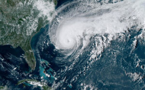
A satellite image of Hurricane Humberto, west of Bermuda, U.S., September 17, 2019. NOAA/Handout via REUTERS. THIS IMAGE HAS BEEN SUPPLIED BY A THIRD PARTY.
Read more at LiveScience.com: Hurricanes are blasting Bermuda with wind speeds that have more than doubled in strength over the last 66 years, due to rising ocean temperatures in the region as a result of climate change, according to a new study.
Within a 62-mile (100 kilometers) radius of Bermuda, the average maximum wind speed of hurricanes increased from 35 to 73 mph (56 to 117 km/h) between 1955 and 2019, the researchers found. This is the equivalent of a 6 mph (10 km/h) increase every decade.
During this time, sea-surface temperatures in the region also increased by up to two degrees Fahrenheit (1.1 degrees Celsius), according to the Bermuda Atlantic Time Series (BATS), a long-running dataset collected by the Bermuda Institute of Ocean Sciences.
Scientists already knew that higher sea surface temperatures fuel stronger tropical cyclones. But the new findings show that temperatures below the sea surface also play a key role in how these storms form.
Related: The 20 costliest, most destructive hurricanes to hit the US
“Our research demonstrates the greater relevance of upper-ocean temperatures versus sea-surface temperatures alone in the prediction of hurricane intensity,” lead author Samantha Hallam, a postgraduate student at the National Oceanographic Center and the University of Southampton in the U.K., told Live Science.
Current hurricane forecasts rely heavily on sea-surface temperatures to make predictions. However, the researchers discovered that the temperature of the top 164 feet (50 meters) of the water column could be used to more accurately predict hurricane intensity.